


 Reply With Quote
LOL Come on Stan. Have a little fun with it. I can't wait for the build up and jokes that are going to ensue. Q is going to be a good one. I have special meaning with that one.
Results 1 to 15 of 20
Thread: Name That Winter Storm
-
10-09-2012, 03:12 PM #1


- Join Date
- Feb 2007
- Location
- West Of Boston
- Posts
- 503
Name That Winter Storm
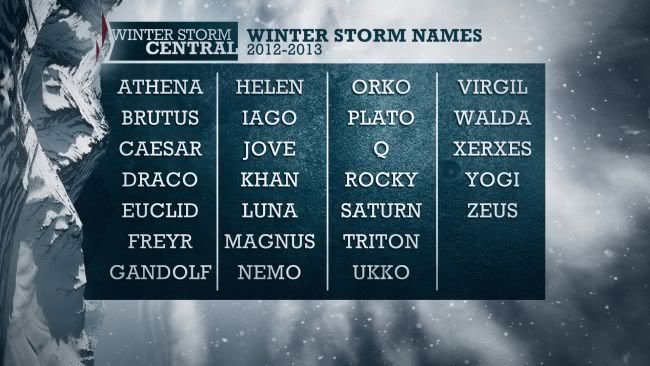
Personally, I think that we do not require any assistance in naming winter storms, but The Weather Channel has decided to try to make things easier for us so that we can simply get out there and ski and ride. Pretty lame names if you ask me. But I will gladly take a Gandolf Storm or a Euclid Storm if they are three feet plus and growing!
During the upcoming 2012-13 winter season The Weather Channel will name noteworthy winter storms. Our goal is to better communicate the threat and the timing of the significant impacts that accompany these events. The fact is, a storm with a name is easier to follow, which will mean fewer surprises and more preparation.
Naming Winter Storms
Hurricanes and tropical storms have been given names since the 1940s. In the late 1800s, tropical systems near Australia were named as well. Weather systems, including winter storms, have been named in Europe since the 1950s. Important dividends have resulted from attaching names to these storms:
Naming a storm raises awareness.
Attaching a name makes it much easier to follow a weather systems progress.
A storm with a name takes on a personality all its own, which adds to awareness.
In todays social media world, a name makes it much easier to reference in communication.
A named storm is easier to remember and refer to in the future.
Stan
"There's No Cure For Life"
-
10-09-2012, 06:08 PM #2

- Join Date
- Oct 2007
- Location
- Just ahead of you in the woods....
- Posts
- 1,823
Trouble with you is the trouble with me,
Got two good eyes but we still dont see!
-
10-09-2012, 06:44 PM #3
- Join Date
- Feb 2007
- Location
- West Of Boston
- Posts
- 503
There may be a lot of spot Q storms, but I understand that the long term snow forecast on The Weather Channel is calling for a Zeus of a snow storm on January 26th! Originally Posted by Hawk

Last edited by gostan; 10-09-2012 at 07:22 PM.
Stan
"There's No Cure For Life"
-
10-10-2012, 07:14 AM #4
- Join Date
- Oct 2007
- Location
- Just ahead of you in the woods....
- Posts
- 1,823
I was thinking "Helen the stomn that launched a 1000 powder runs" Originally Posted by gostan
Trouble with you is the trouble with me,
Got two good eyes but we still dont see!
-
10-10-2012, 07:20 AM #5
- Join Date
- Feb 2007
- Location
- West Of Boston
- Posts
- 503
The infamous Yogi (the no longer hibernating winter bear) storm that opened Slidebrook for the season
Stan
"There's No Cure For Life"
-
10-10-2012, 11:14 AM #6

- Join Date
- Dec 2008
- Location
- Champlain Valley
- Posts
- 55
Funny, nowhere on the list do I see Ullr.
-
10-10-2012, 03:42 PM #7
- Join Date
- Oct 2007
- Location
- Just ahead of you in the woods....
- Posts
- 1,823
They are using mostly greek references this year a guess. Maybe they will use a skandinavian (sp?) theme next year. I can think of a few. Helga, Inga, Svetlanna
 Trouble with you is the trouble with me,
Got two good eyes but we still dont see!
-
10-11-2012, 04:51 PM #8
- Join Date
- Mar 2006
- Location
- warren
- Posts
- 1,217
Find Walda
-
10-11-2012, 08:24 PM #9
- Join Date
- Feb 2006
- Location
- New York
- Posts
- 2,597
Im curious to see how this whole thing plays out. Naming a winter storm is a different ballgame than tropical cyclones. The latter form in the atlantic days before they come into the tracking timeframe. Fir the most part , Winter storms on the east coast are a crapshoot until 2 days before and even then there is significant uncertainty.
-
10-12-2012, 06:53 AM #10
- Join Date
- Oct 2007
- Location
- Just ahead of you in the woods....
- Posts
- 1,823
So they name them 2 days before they hit. Or even one day. Not that big a deal. I just think it will be cool that when a biggie hits, it will have a name and we will talk about it for years after. Not just "that storm in 2013 that hit before President's weekend" or something like that.
Trouble with you is the trouble with me,
Got two good eyes but we still dont see!
-
10-12-2012, 06:54 AM #11
- Join Date
- Oct 2007
- Location
- Just ahead of you in the woods....
- Posts
- 1,823
That's good Win! At least you get it.
Trouble with you is the trouble with me,
Got two good eyes but we still dont see!
-
10-25-2012, 02:46 PM #12
- Join Date
- Oct 2007
- Location
- Just ahead of you in the woods....
- Posts
- 1,823
So will Sandy Become Athena!!!!!! Let's se Athena dump on the greens.
Trouble with you is the trouble with me,
Got two good eyes but we still dont see!
-
10-25-2012, 03:32 PM #13
- Join Date
- Feb 2007
- Location
- West Of Boston
- Posts
- 503
I hope so! And, she had better not become an Irene. Snow Only!, Originally Posted by Hawk
Weather baaaaaaad! 'Frankenstorm' could hit East Coast
An unusual nasty mix of a hurricane and a winter storm that forecasters are now calling "Frankenstorm" is likely to blast most of the East Coast next week, focusing the worst of its weather mayhem around New York City and New Jersey.
Government forecasters on Thursday upped the odds of a major weather mess, now saying there's a 90 percent chance that the East will get steady gale-force winds, heavy rain, flooding and maybe snow starting Sunday and stretching past Halloween on Wednesday.
Meteorologists say it is likely to cause $1 billion in damages.
The storm is a combination of Hurricane Sandy, now in the Caribbean, an early winter storm in the West, and a blast of arctic air from the North. They're predicted to collide and park over the country's most populous coastal corridor and reach as far inland as Ohio.
The hurricane part of the storm is likely to come ashore somewhere in New Jersey on Tuesday morning, said National Oceanic and Atmospheric Administration forecaster Jim Cisco. But this is a storm that will affect a far wider area, so people all along the East have to be wary, Cisco said.
Coastal areas from Florida to Maine will feel some effects, mostly from the hurricane part, he said, and the other parts of the storm will reach inland from North Carolina northward.
Once the hurricane part of the storm hits, "it will get broader. It won't be as intense, but its effects will be spread over a very large area," the National Hurricane Center's chief hurricane specialist, James Franklin, said Thursday.
One of the more messy aspects of the expected storm is that it just won't leave. The worst of it should peak early Tuesday, but it will stretch into midweek, forecasters say. Weather may start clearing in the mid-Atlantic the day after Halloween and Nov. 2 in the Northeast, Cisco said.
"It's almost a weeklong, five-day, six-day event," Cisco said Thursday from NOAA's northern storm forecast center in College Park, Md. "It's going to be a widespread serious storm."
With every hour, meteorologists are getting more confident that this storm is going to be bad and they're able to focus their forecasts more.
The New York area could see around 5 inches of rain during the storm, while there could be snow southwest of where it comes inland, Cisco said. That could mean snow in eastern Ohio, southwestern Pennsylvania, western Virginia, and the Shenandoah Mountains, he said.
Both private and federal meteorologists are calling this a storm that will likely go down in the history books.
"We don't have many modern precedents for what the models are suggesting," Cisco said.
It is likely to hit during a full moon when tides are near their highest, increasing coastal flooding potential, NOAA forecasts warn. And with some trees still leafy and the potential for snow, power outages could last to Election Day, some meteorologists fear.
Some have compared it to the so-called Perfect Storm that struck off the coast of New England in 1991, but Cisco said that one didn't hit as populated an area and is not comparable to what the East Coast may be facing. Nor is it like last year's Halloween storm, which was merely an early snowstorm in the Northeast.
"The Perfect Storm only did $200 million of damage and I'm thinking a billion," said Jeff Masters, meteorology director of the private service Weather Underground. "Yeah, it will be worse."
But this is several days in advance, when weather forecasts are usually far less accurate. The National Hurricane Center only predicts five days in advance, and each long-range forecast moves Sandy's track closer to the coast early next week. The latest has the storm just off central New Jersey's shore at 8 a.m. on Tuesday.
As forecasts became more focused Thursday, the chance of the storm bypassing much of the coast and coming ashore in Maine faded, Cisco said.
The hurricane center's Franklin called it "a big mess for an awful lot of people in the early part of next week."Last edited by gostan; 10-25-2012 at 03:53 PM.
Stan
"There's No Cure For Life"
-
10-25-2012, 05:30 PM #14
- Join Date
- Dec 2010
- Location
- Warren, VT
- Posts
- 73
Oh boy....time to check the generator to make sure it works.
-
10-25-2012, 08:44 PM #15
- Join Date
- Feb 2006
- Location
- New York
- Posts
- 2,597
Glad im not living on the beach.

Bookmarks